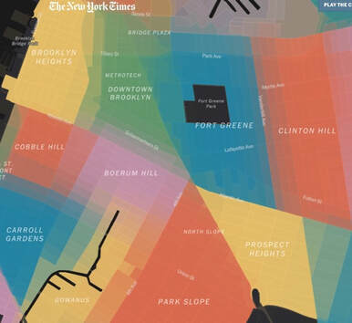
 You might be surprised to learn that New York City does not have official neighborhood boundaries, and some new names have emerged as the product of re-branding by neighborhood boosters and/or real-estate agents. Here an interesting article in the New York Times about the contested boundaries. Note, in the screenshot at left, the boundary zones where the colors aren't solid. History lessons For example, once upon a time there was an undifferentiated area of "South Brooklyn," which referred not to the southern sections of today's Brooklyn, like Coney Island or Bay Ridge, but to the southern part of the old City of Brooklyn, established in 1834, while the rest of Kings County--today co-terminous with Brooklyn--was unincorporated. By the 1960s or so, in an effort to distinguish row-house sections of South Brooklyn from nearby--but separated by a highway--Red Hook, a maritime industrial neighborhood with a massive public housing complex, those boosters conceived of Carroll Gardens and Cobble Hill. There are unusually deep front gardens in Carroll Gardens, though the only hill in Cobble Hill is historical. But it sounds more posh. New questions Today, the debates more concern the effort to expand, or contract, a border. Consider: the border of Prospect Heights, long thought of as Washington Avenue, is no longer fixed, as real estate listings a block or two east of Washington now claim Prospect Heights rather than Crown Heights. See the yellow-to-green section in the bottom right of the screenshot. The logic is that these more upscale apartments have more in common with most of Prospect Heights than much of Crown Heights, which has more working-class blocks, many with rent-stabilized units, to the east. Then again, Crown Heights also has its own historic blocks.
0 Comments
|
Touring Brooklyn BlogObservations and ephemera related to my tours and Brooklyn. Comments and questions are welcome--and moderated. Archives
July 2024
Categories
All
|
 RSS Feed